Wayfinding – Finding your way to new adventures – where and how

Although the majority of trips by bicycle take place on a familiar route, there is still a need for route information and guidance on trips where the cyclist doesn’t know the way. Route information and guidance may take the form of physical traffic and directional signs or digital apps, etc.
Niels Hoé, HOE360 Consulting
Wayfinding and similar information contribute to the coherence of the cycling trip. Regardless of whether you’re biking in town, in open country, or on a wild mountain path, good, accurate guidance to your destination is always helpful and reassuring. This applies to the everyday cycling trip as well as recreational and competitive or professional cycling. In recent years in Denmark there has been a marked increase in interest in the mountain bike as an excellent type of exercise and training, and bicycle route signs play a vital role in preserving a balance between cyclists, walkers and riders, and their impact on the natural environment.
Wayfinding is useful before and during the cycling trip. Printed or digital bicycle maps are excellent planning tools and help cyclists find the local cycling options.
There are also a number of on-line route planners which show the cycle route as well as its estimated duration. Google Maps has a cycling option, and Rejseplanen.dk also includes cycling in the route guidance system.
In addition to the numerous digital options, the good old directional sign is still useful and practical. There are directional signs that show the longer, recreational bicycle routes and others marking the way through the city. The cycle superhighways have their own signage system.
The new kid in town is dynamic signage and directional guidance, opening up new opportunities for real- time communication with cyclists.
Finding your way:
Det samlede net af supercykelstier i Region Hovedstaden har potentiale til at give en række samfundsøkonomiske gevinster.
- Physical signage
- Bicycle maps
- Route planners
- Interactive signage
- Signage for route choice
- Temporary signage
Der er også en række online cykelplannere, som anviser cykelruten og forventet tid turen tager. I Google Maps, kan man vælge cykelrute og Rejseplanen har også fået cyklen ind som transportmulighed, når man planlægger en rejse.
Trods de mange digitale muligheder er det gode gamle vejskilt med tavle stadig anvendelige og praktisk på turen. Der er skilte, som anviser længere rekreative cykelruter, andre viser vej i byen og supercykelstierne har deres eget ruteanvisningssystem.
Nyeste skud på stammen er dynamisk skiltning og anvisningstavler, hvor den teknologiske udvikling åbner nye muligheder for real-time kommunikation med de cyklende.
Read more under ”Bicycle tourism”
Physical signage
The most common type of wayfinding sign is the traditional signpost. Rules and design standards vary, but the guiding principle is that the markings on a given route must be uniform; they must form a cohesive whole so the cyclist is in no doubt as to which route to follow. The signs are usually mounted on stands or racks.
In many ways cyclist wayfinding is precisely the same as wayfinding for motor traffic. The signs are simply smaller and adjusted to the appropriate distance and cycling speed. The signs are designed specifically for cyclists just as signs for walkers or horseback riders have their own icons and design. From the point of view of traffic safety, it makes sense to differentiate between cyclist and motorist signage so there can be no doubt as to which road user group is being targeted.
The Road Rules determine the terminology, the principles for and the design of signage, and the national bicycle route requirements. Revision procedures are described. Certain rules, such as types of sign, bicycle symbols, and colors, are considered normative and are established by law.
Read more here: Håndbog i cykeltrafik samt Vejregler
Cyclist wayfinding should be appropriate to the cycling type and in harmony with the surroundings. Different setups are advisable depending on whether wayfinding is along a road or out in nature.
However, it is crucial that the entire route has a uniform design. In the case of cycle tracks with their own route layout, high stands with directional arrows are worth considering since each stand can replace up to 4 racks.
The next section describes and illustrates examples of signage according to the following two cycling types:
- Everyday signage and recreational signage
- Signage when cycling for sport and exercise
Everyday signage and recreational signage
Everyday signage and recreational signage means a wayfinding system that guides cyclists through a city or between cities, i.e. from one place to another. It’s useful for daily chores and commuting, and also for recreational and tourist cycling. The signage must show the route as well as the attractions along the way so as to enhance the cycling experience.
There are thousands of kilometers of signed Danish bicycle routes. The routes are divided into three categories to make it easier for cyclists to find their way:
- National routes, No. 1-15. White number on a red field, with a white frame (national colors).
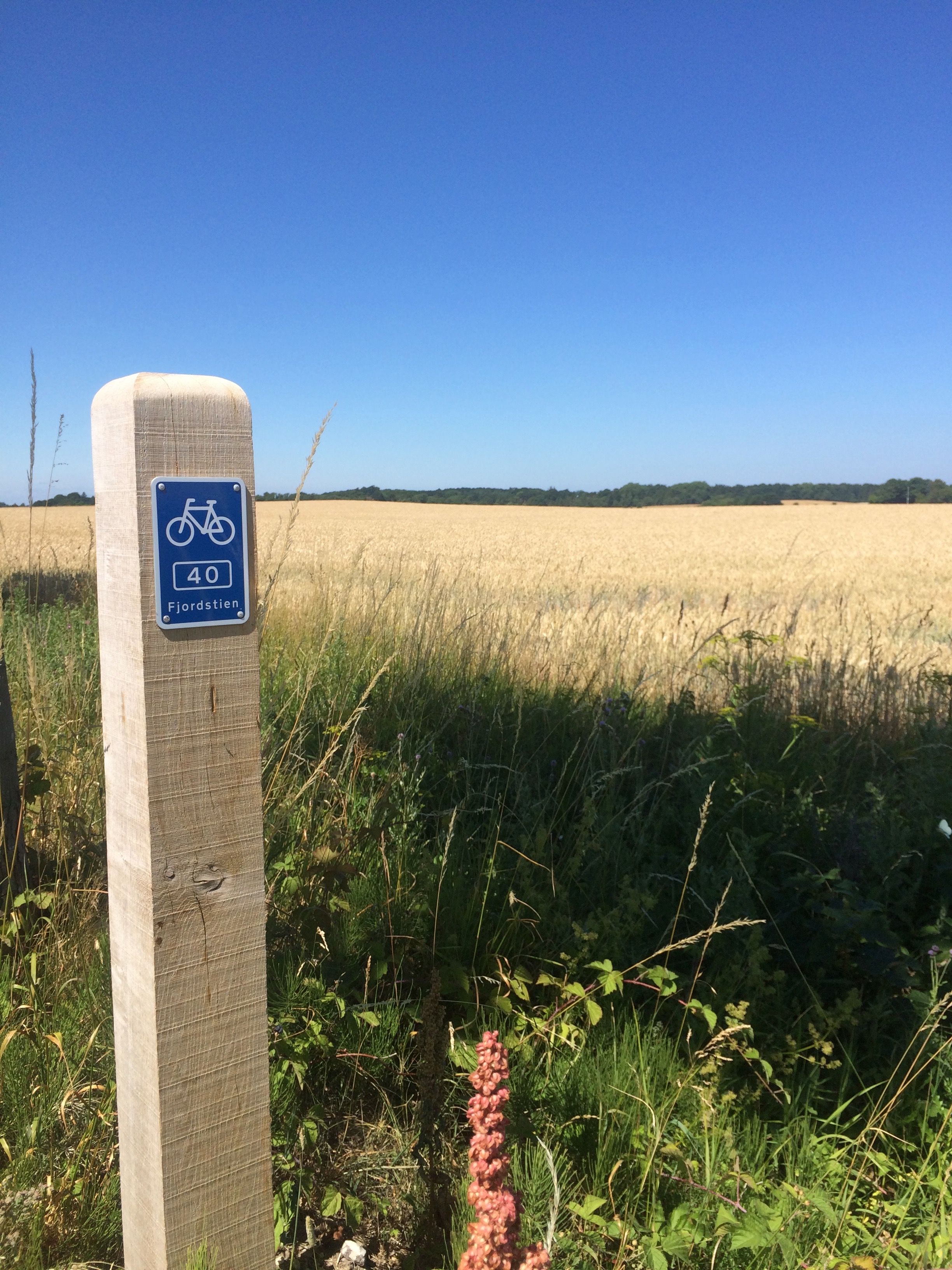
- Regional routes, No. 16-99. White number on a blue background with a white frame.
- Local routes, No. 100-999. White number, name or logo in a white frame on a blue background.
The cycle route number may have a supplementary name. Local routes may simply have a name or merely a logo (for example, a crown to indicate the king’s route (Kongeruten). Logos must be approved by the Danish Road Directorate.

- Example of a marker post.

- Example of a rack post.
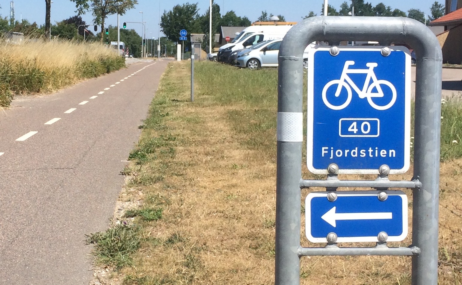
There are also international routes called EuroVelo routes, four of which run along Danish roads. The European routes are marked by a sign placed beneath the national route sign.
Local authorities should draw up signage plans to ensure cycle route cohesiveness. A signage plan analyzes the entire stretch and notes and shows the placement of every single sign and stand, including type, text and icon, etc. In addition, on-going quality control should be carried out, inspecting the route every few years to ensure the route is still easy to follow and that the signs and stands are intact.
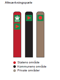
- Examples of marker posts in Danish forests. Red: State area: Black: Municipal area. Brown: Private area

Signage for sport and exercise
There are many mountain bike trails maintained by clubs and volunteers in the great outdoors in Denmark, particularly in the forests. The routes have different levels of difficulty and are increasingly attracting users.
The routes are often marked by a low marker post with a colored circle indicating the trail. The Danish sports association DGI, Danish Cyclists’ Federation, and the Nature Agency have developed a mountain bike signage standard.
In the Danish national forests alone there are more than 500 km of routes, free for anyone to enjoy. You can find inspiration and good advice as well as route maps on the Nature Agency’s website
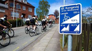
- Vejle’s steep hills are signposted. (Photo: VisitVejle.dk)
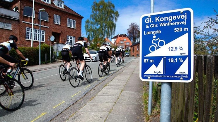
The city of Vejle is known for its steep hills, and it decided to market them as excellent training for cyclists. It has signposted its 25 most popular climbs, and has 16 so-called super routes that enable cyclists to test themselves against Vejle’ s steep gradients. The super routes may be downloaded to a bicycle computer, and the cyclist is guided through the route by GPS.
Not only are most of the hills in Denmark right here, but nowhere else in Denmark are there more asphalted vertical meters within a narrow area.
Sorce: VisitVejle
Bicycle maps – paper and online
Bicycle maps, paper as well as online, are an excellent tool for a town or city to show its citizens and visitors the local cycling options. They are also a planning tool for cyclists. Digital solutions are increasingly replacing the good, old printed bicycle map, which certain towns continue to publish. However, the town website often has maps too, where you can select a bicycle route using GIS.
In 2016 the Danish cycle tourism association published a number of physical bicycle maps for recreational use covering the entire country.
Route planners
Several towns have been active in developing web- based route planners. However, the technology is developing at a rapid rate, and many other players are also developing apps and solutions, for example Google Maps and other map services. Nevertheless it is still relevant for cities and others to develop regional and national route planners with a special focus on cycling, including detailed information and functions, as well as route type (fastest, most scenic, etc.), and elements which may be integrated with public transport and combined journeys.
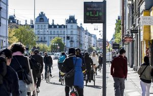
- Copenhagen’s dynamic bicycle signs (photo: City of Copenhagen/ Troels Heien)

Interactive signage
Information about roadworks or traffic congestion that will affect the bicycle trip may also be integrated with the wayfinding material. Copenhagen was the first city in the world to install electronic information signs targeting cyclists.
A total of five signs were installed, all of which are on the way into the city center. The main reason for this choice of direction is that it is the most congested.
Information signs propose routes when roadworks make it difficult to navigate, for example, or provide information on travel times to the closest train station, etc., thereby affecting the cyclist’s choice of route while cycling.
Source:
https://www.kk.dk/nyheder/cyklister-i-koebenhavn-faar-bedre-information-om-traengsel-paa-cykelstien

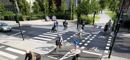
Cycle Superhighway signage
The cycle superhighways have their own wayfinding and marking system, combining traditional vertical signs and horizontal markings. The vision is that the cycle superhighways should become a serious transport alternative on stretches of more than five kilometers, and be able to match other transport offers to and from work and education.
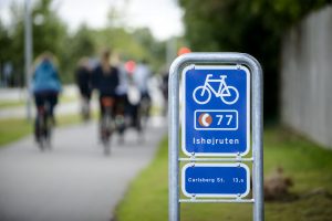
- Photo: Bicycle super highway, Capital Region
This requires a uniform and stringent branding as the design must be easily recognizable and clearly marked, so the cyclist always knows he or she is still on the super highway.
The marking is combined with the classical sign bearing the bicycle super highway logo and the route number.
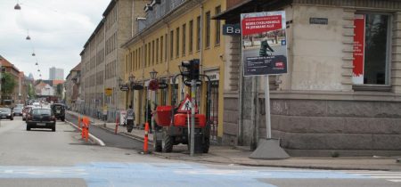
Temporary signage
All cities and other local authorities need to excavate and restructure roads. The time comes when it is necessary to replace underground piping or lay fiber-optic cables, and sometimes a new cycle track needs to be established.
Roadworks sometimes involve changes that affect all road users. Priority is often given to ensuring accessibility for pedestrians and cyclists rather than drivers of motor vehicles. This may be done by temporarily designating a traffic lane for pedestrians or cyclists.
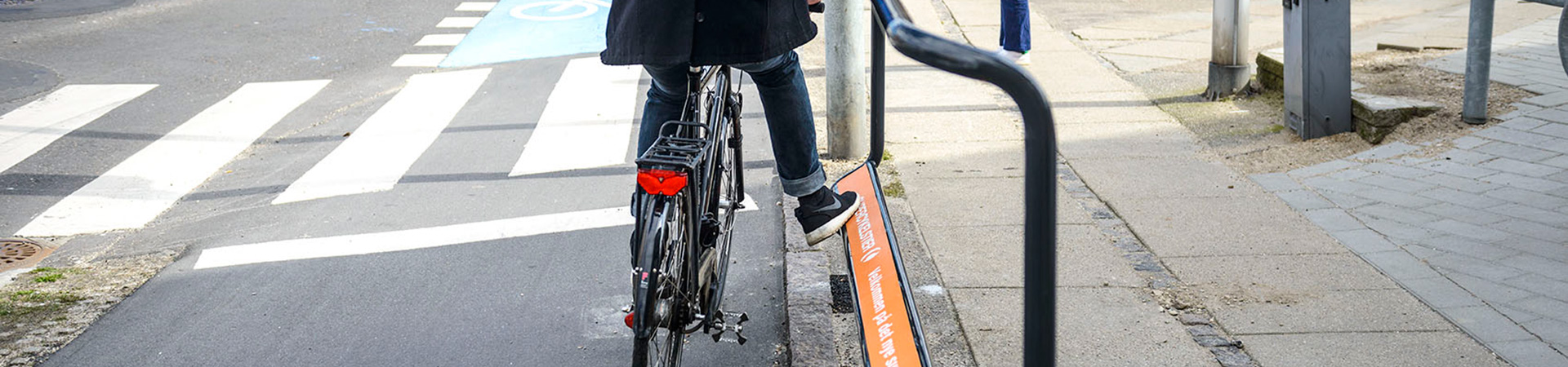
When a road layout is altered or closed, it is vital to inform cyclists, and guide them by signage or other markings in plenty of time to choose an alternate route, preferably before they are confronted with a closed- off road.
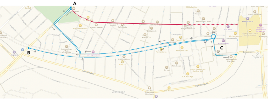
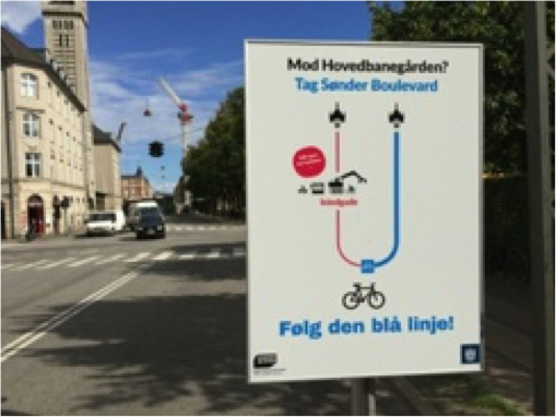
- Example of a temporary wayfinding sign in connection with roadworks. For Copenhagen Central Station: Follow the blue route.