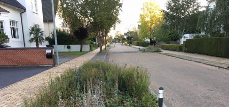
Planning principles
 Photo: Troels Andersen, Odense Municipality
 A bicycle traffic plan should be based on what’s already there and what cyclists already have. City and country are two highly different things, and the type of city also makes a big difference. What should be the central focus of country planning, ensuring mobility for the citizens or catering to tourist needs?
By Troels Andersen, Odense Kommune
Cycling infrastructure can be developed according to different principles. Existing infrastructure is often fine, but let’s leave it aside for a moment and take a look at cycling solutions based on general principles.
In a city, current traffic volumes registered by traffic counts can be an excellent starting point for improving conditions for as many cyclists as possible with the given allocations.
The potential for increased bicycle traffic (for example many workplaces) may also be included in the prioritization. There is also an excellent potential in a situation where a cycle path will create a secure school route thereby enabling a number of children to cycle instead of being driven by car or bus. It’s a good idea to include the so-called trip rates, i.e. the table values of the estimated number of trips generated by a supermarket or a housing development.
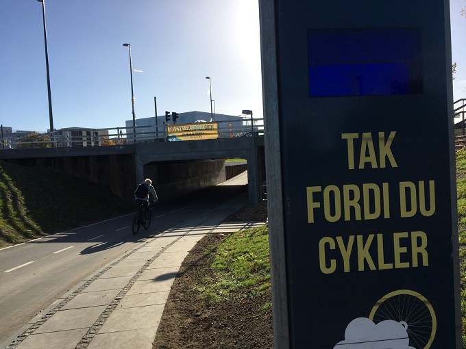
- A bicycle tunnel with a clear line of sight creates an excellent link between two separate urban areas. Photo: Troels Andersen
On roads without cycle tracks prioritization may be based on the estimated number of potential cyclists. This may be done by a professional assessment or based on a traffic model that includes bicycle traffic.
For safety reasons, roads with many cars and high speeds but few cyclists should have cycle tracks. When there isn’t a great deal of current bicycle traffic, the cyclist potential should be the decisive factor. This is often the case when it comes to new construction where a large cycling share may be expected under the right conditions. Bridges can also create new types of cohesion, switch transport modes and encourage many new cycle trips.
Another issue is the question of one-way streets in city centers and residential areas. However, counts of illegal counter-flow cyclists cannot be used for purposes of assessment. In some streets legalization of counter-flow cycling gives cyclists a short-cut and hence results in more cyclists.
In addition to current and potential bicycle traffic volume it’s also important to know the location of destinations and how they may be linked. Mapping can sometimes be an answer, but valuable input can be gained by taking the destination rather than the bicycle traffic volume as the starting point to show where there are missing links in the cycling infrastructure and to point to other solutions than the traditional cycle tracks along longer roads.
Car traffic volume, speed and in some cases also the age distribution of cyclists can and should affect the choice between cycle track, cycle lane and mixed traffic lanes. A high standard for principles of intersection design is crucial and should have high priority.
The size and structure of Danish municipalities varies greatly, and so bicycle planning must be approached in very different ways. Copenhagen Center, Frederikshavn, and Albertslund have been selected as examples.
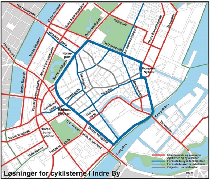
- City of Copenhagen Bicycle Track Priority Plan 2017-2025. Colour codes: Red: Existing or planned cycle tracks and cycle lanes. Blue: Recommended cycle corridors. Green: Recommended green cycle routes. Grey: Pedestrian streets and main transport structure
Download “Københavns Kommunes Cykelstiprioriteringsplan 2017-2015” in Danish (PDF)
In urban areas an appropriate cycle infrastructure mesh is 3-700 m. By laying such a mesh on the plan it’s possible to assess the cycle track network’s cohesiveness.
In rural areas it’s necessary to plan for everyday traffic (commuter cycling, cycling to school, etc.) as well as recreational and holiday cycling. Since traffic volumes in the country are much lower than in cities, traffic counts in the country are much less suitable as a planning tool since the counts are low, and coincidence plays too great a role. Consequently in rural areas, in addition to mapping concrete destinations, important parameters are the catchment area, the collective traffic structure, and registered accidents. If in the country you don’t own a car or may not drive a car, the bicycle is often the main transport mode since busses are few and far between. In this case a cycle track may be the most important means of mobility for many people.
When it comes to recreational and holiday cycling it is important to link planned infrastructure in cities with cycle tracks along country roads and existing and planned cycle routes, including cycle tracks with their own route. Although natural sites, beaches and other attractions are essential factors in the experience, holiday cyclists in particular also need to cycle through cities to shop, but also for the sake of variety. It should also be possible to reach accommodation such as campsites, hostels and hotels without having to bike the last 5 km in the dark on a road with fast moving motor traffic.
In rural areas it may initially be a good idea to plan everyday cycling and recreational and holiday cycling separately. For recreational cyclists the first step could be a corridor route. Then come the existing national and regional cycle routes, a cycle track along a stream or a potential track on a disused railway. Finally you look for overlaps and coordination potential, which will primarily be possible near cities and in the transition between city and country.
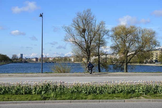
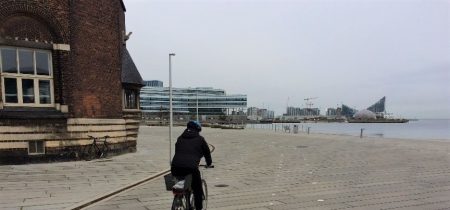
- When you bike by the water you know where you are, and you can enjoy the view. Photo: Cycle superhighways, Capital region of Denmark.
Cycle tracks along main roads both in cities and in the country are often more logical and easier to navigate than cycle tracks with their own layout or routes along local roads. This is especially true for new cyclists who are either used to driving or are new in town. Confusing changes of direction along the cycle route can baffle cyclists. Landmarks can help cyclists find their way.
Uniform design over long routes is an important component of cycle routes. Good signage can even make disparate cycling infrastructure elements fairly cohesive. Some cities have chosen to mark special routes with reflectors, raised pavement markers, or manholes with cycle symbols as a supplement to ordinary wayfinding signage.
Cycle routes which can be seen from the road, and human activity in general, create a greater sense of security. When the cycle route is hidden away from other road users, cyclists tend to feel more threatened, and fast moving mopeds can be a problem on cycle tracks with their own layout. Cycle tracks with their own layout may thus sometimes be less suitable because of a feeling of social isolation. Lighting, open construction and planting trees and shrubbery can make up for this to a certain extent.
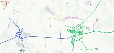
Frederikshavn
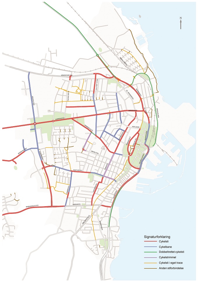
- Red: cycle track. Blue: cycle lane. Green: two-way cycle track. Purple: cycle track with its own layout. Yellow: cycle tunnel. Brown: other cycling connections.
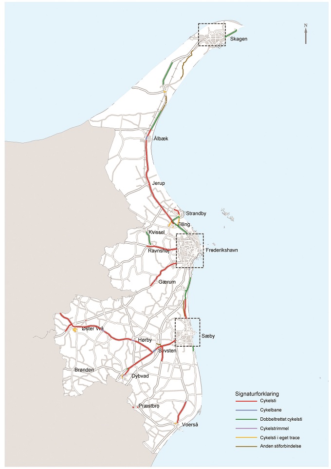
Frederikshavn Municipality’s plans for expanding the cycle track network in the three main cities of Skagen, Sæby, and Frederikshavn and in open country. One map shows the existing cycle tracks in country areas and the other shows the plans for developing the cycle track network in the city of Frederikshavn.
Frederikshavn municipality has drawn up a bicycle policy. One of its 7 focus areas includes plans for developing the cycle track network in the three main cities of Skagen, Sæby and Frederikshavn, and in open country. Cycling infrastructure plans are on the way for everyday cycling in cities, rural school routes, and recreational paths. A cycle track has been established all the way from Frederikshavn to Skagen for the benefit of Skagen’s tourists, among others. The authority has studied options for establishing baggage transport, and whether there are accommodation establishments that can be marketed as cycle friendly. The cycle policy was drawn up in connection with Nordic Cycling Cities and received EU funding.
Albertslund
Albertslund planlægger stiforbindelserne ud fra følgende principper:
- That maintaining a differentiated traffic system should be reinforced by municipal plans and projects.
- That a network of commuter tracks should be established ensuring high accessibility within and across municipal boundaries.
- That plans should be drawn up for establishing the missing cycle track links with a special focus on:
- Commuter tracks
- The area around Albertslund Center
- The commercial areas
- That cycle tracks with links to the cycle track network should be established whenever traffic hubs are constructed (light rail stations, bus stops for more busses).
- That access to the cycle track network should be ensured to the greatest possible extent through the work with local plans, land development, etc.
- That motor traffic should be limited to the greatest possible extent wherever motor traffic is allowed along the main cycle track network.
- That the local authority should enter into and support the strategic work for better national and regional cycle track links.
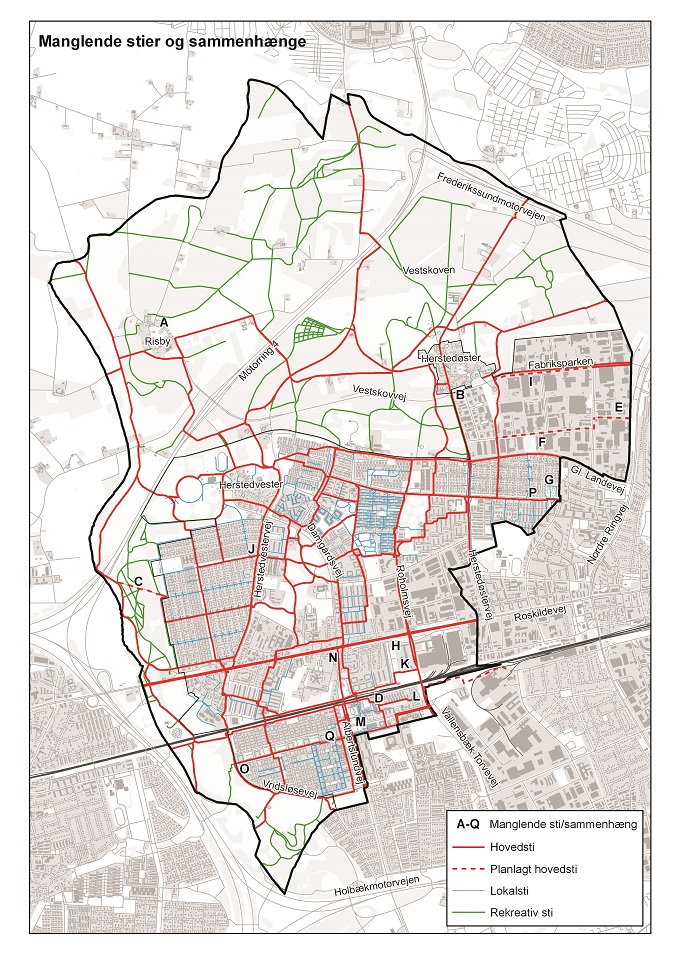
- Missing cycle tracks and cohesion in Albertslund Municipality. Red: Main route. Red dotted: Planned main route. Green: Local route. Grey: Recreational route. Source: Albertslund Municipality, Cycle track plan
Principles for cycle track planning - Examples
- Odense Municipality has for many years used traffic counts from within the city center and outwards as the basis for its prioritization. The question of where the greatest number of people will benefit from a new cycle track is weighed against construction costs.
- Aalborg Municipality formerly used a model developed by the counties: potential school route cyclists; a factor for the cyclist group favored (work, leisure); and economy (city/country balance)
- The City of Copenhagen uses professional cycling criteria in their cycle track priority plan: many cyclists; accidents, lack of security; cycle track network cohesiveness;contra-flow cycling. In addition, options for coordinating with other city projects, and the question of whether bicycle track infrastructure can be established cheaply and easily.
Københavns Kommune bruger cykelfaglige kriterier i deres cykelstiprioriteringsplan: mange cyklister, ulykker, utryghed, sammenhæng i nettet, cykling mod ensretningen. Dertil kommer muligheden for koordinering med andre projekter i byen, og om cykelinfrastrukturen kan etableres enkelt og billigt.
Albertslund is organized on the principle of traffic differentiation. Albertslund South is a large, differentiated residential area which was traffic calmed around 1980, when some of the roads were opened to bicycle traffic, both lengthwise and crosswise. Commercial areas in Albertslund are not traffic differentiated. The local authority is working to improve bicycle commuting facilities linking the existing network of segregated cycle tracks with a new network of Cycle superhighways in the capital region.
Albertslund Municipality Bicycle Strategy of 2009 aims to improve cycling conditions in Albertslund in order to encourage residents and wage earners to choose the bicycle rather than the car. The objective is to increase bicycle traffic by 10% between 2009 -2015. This will reduce CO2 emissions and benefit the environment as well as improving public health. The strategy also aims at improving accessibility, availability, and security. The authority has a focus on traffic safety with a special focus on cycle tracks and roads outside the segregated cycle track system.
Plans for the cycle track network should ensure that the network covers the entire municipal area, and that the cycle track network provides access from residential areas to all the city’s functions, including work places, institutions, and shopping. The plans must also ensure access to the authority’s recreational areas and especially provide attractive links to the neighboring districts.
Sources
Flere cykler. Opfølgning på byrådets cykelpolitik, Frederikshavn Kommune 2011.
Friluftsrådet, 2011, Stier – inspiration til planlægning og forvaltning. www.friluftsrådet.dk (se politik og derefter planlægning).
Trafiksanering i en bydel med trafikadskillelse (Albertslund Syd). I Planlægning for cyklister, hverdag og fritid. Miljøministeriet, 1985.
Cykelstrategi 2016 – 20, Albertslund Kommune. 2015